Credit: NASA · NASA material is generally not copyrighted; items carrying a third-party or copyright credit are excluded. The NASA logo and insignia are never reused.
NASA
Earth Observatory
Science
Earth Observatory
Before the Dawn in America’s…
Earth
Earth Observatory
Image of the Day
EO Explorer
Topics
All Topics
Atmosphere
Land
Heat & Radiation
Life on Earth
Human Dimensions
Natural Events
Oceans
Remote Sensing Technology
Snow & Ice
Water
More Content
Collections
Global Maps
World of Change
Articles
Earth Matters Blog
Blue Marble: Next Generation
EO Kids
Mission: Biomes
About
About Us
Subscribe
🛜 RSS
Contact Us
Search
October 18, 2026
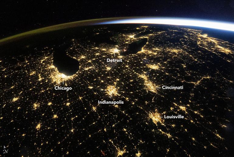
The predawn hours brought clear skies over much of the eastern United States on October 18, 2026. An astronaut aboard the International Space Station seized the opportunity to capture this wide-angle photo at 4:54 a.m. Central Daylight Time (09:54 Universal Time), with illuminated cities large and small arrayed across the darkened landscape.
The U.S. Midwest’s largest metropolitan areas, such as Chicago, Illinois, and Detroit, Michigan, stand out as some of the brightest features. Mid-sized cities—including Indianapolis, Indiana; Cincinnati, Ohio; and Louisville, Kentucky—and their interconnections along state and interstate highways also shine brightly.
Above the web of nighttime lights and Earth’s lower atmosphere, a diffuse layer of green and orange is visible along the horizon to the left. This band of light is airglow, produced when sunlight strikes atoms and molecules in the upper atmosphere and causes them to eject photons. To the right, light from the Sun arcs across the horizon; sunrise was about an hour away on the East Coast and about two hours away in Chicago.
Astronaut photos and other remote sensing observations of nighttime lights are scientifically valuable for tracking changes in the built environment. For example, Chicago’s lightscape appears a homogeneous pale yellow in the wide view above. But in detailed photos, like the one below, a range of colors stemming from different types of lighting is discernible. Using NASA’s extensive Gateway to Astronaut Photography of Earth archive, researchers have developed a method for distinguishing lighting types within the pixels of nighttime photos. Systematically quantifying urban lights’ brightness, color, and extent can provide insight into how cities grow and evolve.
March 1, 2024
Satellite sensors also observe changes to lighting. In particular, NASA’s Black Marble nighttime lights product suite uses satellite observations to produce science-quality records of nighttime lights across the globe at daily, monthly, and yearly time scales. In the eastern U.S., scientists have used these data to track everything from power outages and restoration following major storms to lighting changes associated with new infrastructure to transitions to LED lighting from older forms.
Astronaut photograph ISS075-E-226709 was acquired on October 18, 2026, with a Nikon Z9 digital camera using a focal length of 14 millimeters, and photograph ISS070-E-105097 was acquired on March 1, 2024, with a Nikon D5 digital camera using a focal length of 400 millimeters. They are provided by the ISS Crew Earth Observations Facility and the Earth Science and Remote Sensing Unit at NASA Johnson Space Center. The images were taken by members of the Expedition 75 and Expedition 70 crews, respectively. The images have been cropped and enhanced to improve contrast, and lens artifacts have been removed. The International Space Station Program supports the laboratory as part of the ISS National Lab to help astronauts take pictures of Earth that will be of the greatest value to scientists and the public, and to make those images freely available on the internet. Additional images taken by astronauts and cosmonauts can be viewed at the NASA/JSC Gateway to Astronaut Photography of Earth. Story by Lindsey Doermann.
Downloads
October 18, 2026
JPEG (8.59 MB)
March 1, 2024
JPEG (21.81 MB)
References & Resources
NASA Earth Observatory (2026, May 15) Picturing Earth in a New Light. Accessed November 3, 2026.
NASA Earth Observatory (2024, November 24) Windy City of Lights. Accessed November 3, 2026.
NASA Earth Observatory (2017, December 27) Observing Changes in Nighttime Lights. Accessed November 3, 2026.
You may also be interested in:
Stay up-to-date with the latest content from NASA as we explore the universe and discover more about our home planet.
An Epic View of the Seasons
6 min read
The tilt in Earth’s axis of rotation makes the apparent position of continents shift with the seasons in imagery from…
Article
Moon-Like Madagascar
3 min read
A bright lens of anorthosite, a rock type prevalent on the lunar surface, is cradled within sheared rocks in the…
Article
The World Cup From 250 Miles Up
4 min read
Over the years, astronauts aboard the International Space Station have photographed several of the cities hosting the 2026 FIFA World…
Article
1
2
3
4
Next
Keep Exploring
Discover More from NASA Earth Science
Subscribe to Earth Observatory Newsletters
Subscribe to the Earth Observatory and get the Earth in your inbox.
Earth Observatory Image of the Day
NASA’s Earth Observatory brings you the Earth, every day, with in-depth stories and stunning imagery.
Explore Earth Science
Earth Science Data
Open access to NASA’s archive of Earth science data