Credit: NASA · NASA material is generally not copyrighted; items carrying a third-party or copyright credit are excluded. The NASA logo and insignia are never reused.
NASA
Earth Observatory
Science
Earth Observatory
Floodwaters Overwhelm Thailand
Earth
Earth Observatory
Image of the Day
EO Explorer
Topics
All Topics
Atmosphere
Land
Heat & Radiation
Life on Earth
Human Dimensions
Natural Events
Oceans
Remote Sensing Technology
Snow & Ice
Water
More Content
Collections
Global Maps
World of Change
Articles
Earth Matters Blog
Blue Marble: Next Generation
EO Kids
Mission: Biomes
About
About Us
Subscribe
🛜 RSS
Contact Us
Search
October 7, 2025
October 2, 2026
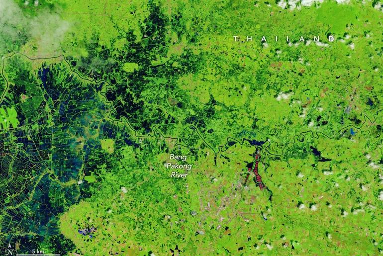
A narrow river (dark blue) meanders across vegetated land (bright green) in a false-color satellite image. Small geometric ponds or waterlogged fields appear on the left side of the scene.
NASA Earth Observatory / Lauren Dauphin
In a false-color satellite image of the same area, floodwaters (dark blue) flank a meandering river and cover a large swath of agricultural or aquacultural land primarily on the left side of the scene.
NASA Earth Observatory / Lauren Dauphin
October 7, 2025October 2, 2026
A narrow river (dark blue) meanders across vegetated land (bright green) in a false-color satellite image. Small geometric ponds or waterlogged fields appear on the left side of the scene.
NASA Earth Observatory / Lauren Dauphin
In a false-color satellite image of the same area, floodwaters (dark blue) flank a meandering river and cover a large swath of agricultural or aquacultural land primarily on the left side of the scene.
NASA Earth Observatory / Lauren Dauphin
October 7, 2025
October 2, 2026
CurtainToggle2-Up
September falls in the heart of the monsoon season in Thailand, where cities and towns are accustomed to the afternoon rains and thunderstorms that frequently roll through. But throughout late September and early October 2026, persistent heavy rains punctuated by intense downpours left low-lying areas across the country in Southeast Asia under sustained flooding.
Prachin Buri province was among the areas where flooding was widespread. The right image above shows land along the Bang Pakong River and nearby agricultural areas and aquaculture facilities inundated on October 2, 2026. The left image shows the same area at the same time of year in 2025. Acquired with NASA-USGS Landsat satellites, the images are false-color to better distinguish water from vegetation, developed land, and other surfaces. The bright red shapes are floating solar arrays.
Some of the flooding likely stemmed from a low-pressure system that stalled over the area for several days in late September. Stoked by moisture and energy from the warm Gulf of Thailand nearby, the system delivered especially intense rains to the region. About 100 kilometers (60 miles) to the west, Bangkok received nearly 300 millimeters (11.8 inches) of rain over a 48-hour period, according to news reports, close to the average monthly rainfall total for September of 344 millimeters (13.5 inches).
Since mid-September, flooding has occurred in 50 provinces across the country, affecting over 4 million people and causing dozens of deaths, according to the International Federation of Red Cross and Red Crescent Societies. Government agencies estimate about 270,000 hectares (670,000 acres) of farmland, including rice fields and fruit orchards, have been damaged.
NASA Earth Observatory images by Lauren Dauphin, using Landsat data from the U.S. Geological Survey. Story by Lindsey Doermann.
Downloads
October 7, 2025
JPEG (3.56 MB)
October 2, 2026
JPEG (3.79 MB)
References & Resources
ABC News (2026, September 28) Residents brave floodwater for supplies after Bangkok inundated. Accessed October 7, 2026.
The Conversation (2026, October 5) As the planet warms, cities like Bangkok could be increasingly inundated by deadly floods. Accessed October 7, 2026.
The Nation (2026, October 7) Thailand floods hit 1.7m rai including over 26,000 rai of orchards. Accessed October 7, 2026.
ReliefWeb (2026, October 6) THA: Flood – 09-2026 – Heavy rainfall caused flooding #3. Accessed October 7, 2026.
You may also be interested in:
Stay up-to-date with the latest content from NASA as we explore the universe and discover more about our home planet.
Rains Swamp the Gandak River
3 min read
After days of torrential rain, the river rose to record-breaking levels in parts of Nepal and India.
Article
An Agricultural “Island” in the Saskatchewan River Delta
3 min read
Surrounded by wetlands, Manitoba’s northernmost farmland near The Pas turns from green to brown over the 2026 growing season.
Article
The Birthplace of the United States
3 min read
It was here the founders shaped the future of American government.
Article
1
2
3
4
Next
Keep Exploring
Discover More from NASA Earth Science
Subscribe to Earth Observatory Newsletters
Subscribe to the Earth Observatory and get the Earth in your inbox.
Earth Observatory Image of the Day
NASA’s Earth Observatory brings you the Earth, every day, with in-depth stories and stunning imagery.
Explore Earth Science
Earth Science Data
Open access to NASA’s archive of Earth science data