Credit: NASA · NASA material is generally not copyrighted; items carrying a third-party or copyright credit are excluded. The NASA logo and insignia are never reused.
NASA
Earth Observatory
Science
Earth Observatory
Moon-Like Madagascar
Earth
Earth Observatory
Image of the Day
EO Explorer
Topics
All Topics
Atmosphere
Land
Heat & Radiation
Life on Earth
Human Dimensions
Natural Events
Oceans
Remote Sensing Technology
Snow & Ice
Water
More Content
Collections
Global Maps
World of Change
Articles
Earth Matters Blog
Blue Marble: Next Generation
EO Kids
Mission: Biomes
About
About Us
Subscribe
🛜 RSS
Contact Us
Search
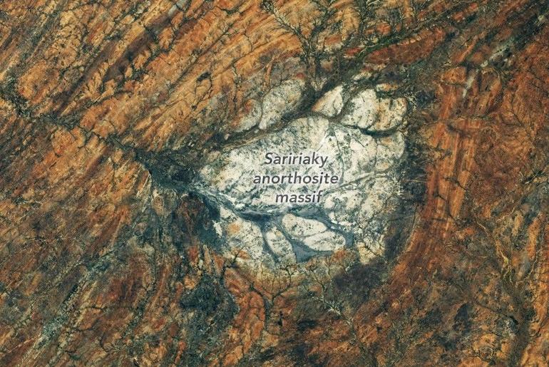
From an astronaut’s perspective looking back at Earth, a patch of bright rock in arid southern Madagascar may appear out of place. But it wouldn’t on the Moon. The igneous rock anorthosite, common on the Moon’s surface, is visible from Earth with the unaided eye as the light-colored, highly reflective areas known as the lunar highlands. Anorthosite also crops up across Earth’s surface, from eastern Canada and Scandinavia to southern India and Madagascar, where it forms a striking round feature.
An astronaut aboard the International Space Station captured this photo of the Saririaky anorthosite massif on August 28, 2026. Anorthosite is an intrusive igneous rock—formed from magma that cools beneath the surface—made up of large mineral crystals. Scientists think the massif seen here formed in the late Precambrian, at least 600 million years ago. Its present-day outcrop covers about 100 square kilometers (40 square miles).
The rocks surrounding the anorthosite reveal a dynamic chapter in the area’s geologic past. Researchers have determined that the Saririaky massif lies within a ductile shear zone, where high pressures and temperatures metamorphosed and reshaped the rock, imparting north-south-trending linear patterns.
Geologists think this deformation occurred when pieces of what are now Africa, India, Madagascar, Australia, and Antarctica were colliding to form the supercontinent Gondwana. Some scientists have posited that another anorthosite massif in the shear zone, located about 60 kilometers (40 miles) to the north, was pulled apart from the Saririaky massif in the process, creating a large-scale boudinage structure.
Anorthosites on Earth have proven useful for scientists studying the Moon’s past. Lunar anorthosites are more than 4 billion years old, having crystallized from the Moon’s magma ocean to form its outer crust. Researchers have analyzed samples brought back to Earth by Apollo astronauts, but because that material is limited, they also look to analogous terrestrial rocks. The anorthosites in the Beartooth Mountains of Montana match the composition of the lunar version particularly well.
Astronaut photograph ISS075-E-85249 was acquired on August 28, 2026, with a Nikon Z9 digital camera using a focal length of 400 millimeters. It is provided by the ISS Crew Earth Observations Facility and the Earth Science and Remote Sensing Unit at NASA Johnson Space Center. The image was taken by a member of the Expedition 75 crew. The image has been cropped and enhanced to improve contrast, and lens artifacts have been removed. The International Space Station Program supports the laboratory as part of the ISS National Lab to help astronauts take pictures of Earth that will be of the greatest value to scientists and the public, and to make those images freely available on the internet. Additional images taken by astronauts and cosmonauts can be viewed at the NASA/JSC Gateway to Astronaut Photography of Earth. Story by Lindsey Doermann.
Downloads
August 28, 2026
JPEG (8.86 MB)
References & Resources
Ashwal, L.D., et al. (1998) Geology, petrology and isotope geochemistry of massif-type anorthosites from southwest Madagascar. Contributions to Mineralogy and Petrology, 133, 389-401.
Earth & Solar System (2017, July 27) Impact Shock State of the Lunar Highlands. Accessed October 2, 2026.
Martelat, J., et al. (2000) Strain pattern and late Precambrian deformation history in southern Madagascar. Precambrian Research, 102, 1–2.
NASA Earth Observatory (2020, May 4) Montana’s Moon-Like Rocks. Accessed October 2, 2026.
You may also be interested in:
Stay up-to-date with the latest content from NASA as we explore the universe and discover more about our home planet.
A Moonlit Earth as Seen From Artemis II
4 min read
An astronaut’s photo, taken en route to the Moon, reveals our planet and its place in space in a novel…
Article
An Epic View of the Seasons
6 min read
The tilt in Earth’s axis of rotation makes the apparent position of continents shift with the seasons in imagery from…
Article
The World Cup From 250 Miles Up
4 min read
Over the years, astronauts aboard the International Space Station have photographed several of the cities hosting the 2026 FIFA World…
Article
1
2
3
4
Next
Keep Exploring
Discover More from NASA Earth Science
Subscribe to Earth Observatory Newsletters
Subscribe to the Earth Observatory and get the Earth in your inbox.
Earth Observatory Image of the Day
NASA’s Earth Observatory brings you the Earth, every day, with in-depth stories and stunning imagery.
Explore Earth Science
Earth Science Data
Open access to NASA’s archive of Earth science data